Campfire bans, air quality advisories and flames much closer to civilization than most would prefer dominated headlines during the 2015 summer season.
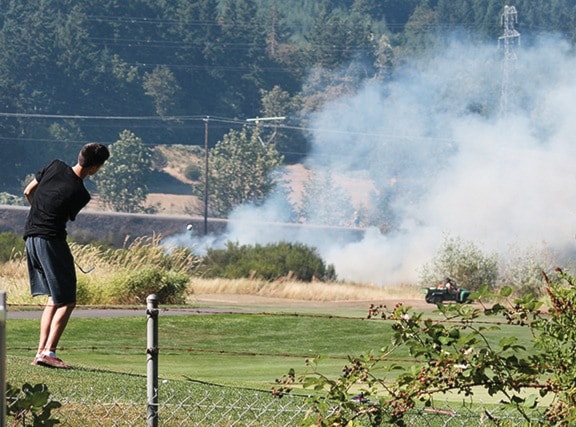
Wildfires were a real danger to the region's tinder-dry forests with the first significant threat coming in the final weeks of July at Duncan Meadows golf course.
A brush fire at the course prompted a full scale response from North Cowichan's South End fire hall with mutual aid from crews from Duncan, Crofton, Maple Bay, and Sahtlam as well.
They wanted to be safe rather than sorry.
Firefighters were well into it on multiple fronts by the time the B.C. Forest Service arrived with more personnel and a helicopter. Highway 18 was closed because smoke was thick and the fire was on both sides.
It was just a sign of things to come.
A fire near Skutz Falls had crews working from the end of July and into August.
That blaze maxed out at about 16 hectares before it was extinguished. It was one of the two bigger fires in the region.
While the Skutz fire was still burning, but contained, a second fire was discovered along the Copper Canyon Mainline (Hill 60) on Aug. 2.
That one was not an offshoot of the Skutz Falls fire, Fire Information Officer Donna MacPherson stressed, but a second, completely separate human caused fire.
It ran about 7.5 hectares before it was put out.
A third, albeit small, wildfire burned at the top end of Meade Creek in August.
Lightening striking the top of a tree was to blame for that fire.
"It's in a fairly remote area on a mountain called Mount Holmes, about three kilometers north of Lake Cowichan," MacPherson said.
A fourth, but relatively small, fire at Kingburne (Cobble Hill) had nearby residents armed with hoses and sprinklers and making plans to move livestock as it crept close to homes and farms. A cigarette butt from a passerby seems to have been the culprit there.
"I always had in my mind to protect the house with a plan," resident John James noted. "Sprinklers on poles were set up in quick order with a rotating sprinkler on top of each. Reached all roofs and 30 feet beyond. We were pretty well covered."
The family watched from a safe distance as three Forest Service helicopters made drops from above using water from the quarry while members of the Cowichan Bay, Maple Bay, Shawnigan Lake volunteer fire departments and a BC Forest Service crew tackled things from the ground, pumping water up from the river in the rural location.
The biggest fire of all was near Lizard Lake, just outside the CVRD, near Port Renfrew, though it's command base was set up within the CVRD's borders.
It was significant enough to be listed by the B.C. Wildfire Service as a "wildfire of note."
The blaze was discovered around midnight Aug. 11 and ultimately closed the Pacific Marine Circle Route and popular area recreation spots as a result.
Raging for weeks because of tough terrain and weather that was less than helpful, the Lizard Lake fire prompted air quality advisories after Cowichan was covered in a fog of ash.
Smoke played an issue in trying to accurately estimate the fire's actual size but it topped out at close to 400 hectares.
That fire is also believed to be caused by humans.