More than 6,000 properties in northern B.C. are under an evacuation alert, leaving hundreds of residents preparing to have to leave their home at a moment’s notice.
BC Wildfire Service has added a handful of new blazes to its Wildfires of Note – defined as ones that are highly visible or have the potential to threaten public safety. The 38 listed include major fires burning in each fire centre across the province.
BC Wildfire Service provincial information officer Ryan Turcot told Black Press Media while there is currently no fire centre not dealing with a wildfire of note, the northern regions are seeing the brunt of fire activity.
“We are seeing notably aggressive fire behaviour still in the Northwest Fire Centre as well as the Cariboo Fire Centre,” he said in a phone interview Saturday.
On Friday, the Cariboo Regional District issued an evacuation alert for 1,700 properties in the city of Quesnel due to the Narcosli Creek Fire burning at an estimated 3,100 hectares. That number has since grown to about 5,900 properties located west of the city amid the surrounding areas on the west side of the Fraser and Highway 97.
That’s in addition to 396 properties northeast of 100 Mile House and 181 properties in and around the community of Springhouse where residents have been told to prepare to pack up.
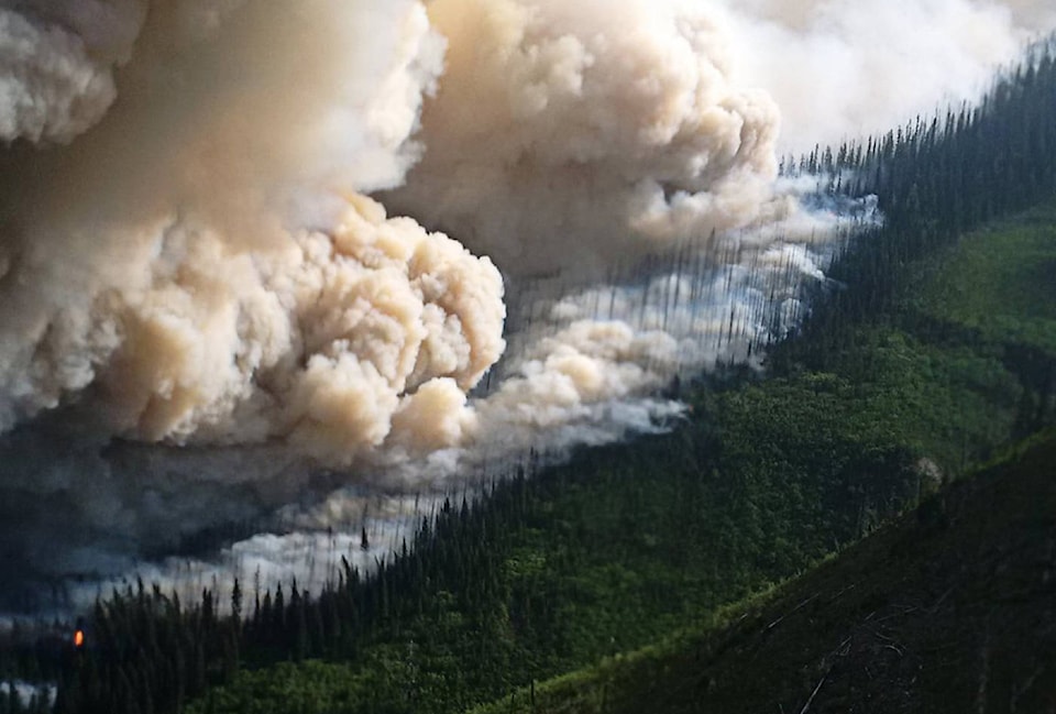
Meanwhile, helicopter evacuations are underway in northwestern British Columbia as wildfires burning near the city of Prince George have forced nearly 900 properties under an evacuation order north of Prince George in the Nazko area.
Emily Epp from the Cariboo Regional District says the wildfire cut off access to a forestry service road, prompting the RCMP to evacuate at least four families by chopper.
| Flames show major wildfires, dots show each fire location and red fades show evacuation orders/alerts. (BC Wildfire Service) |
Residents in the area are being evacuated to an emergency reception centre in Prince George, roughly 250 kilometres northeast of the evacuation zone, which was expanded to over 900 properties on Saturday.
Other evacuation orders are in effect in Telegraph Creek, 23 kilometres northeast of Radium Hot Springs and southeast of Terrace around the Shovel, Torkelson and Nadina lakes.
READ MORE: Holy smokes! Wildfires cause air quality advisory in Lower Mainland
The Nanaimo Lakes wildfire is the largest blaze on Vancouver Island, among others near Port Alberni, Crofton and Sooke and more than a dozen others in the Coastal Fire Centre’s mainland boundaries including in Hope and Agassiz.
Despite a thunderstorm this morning that saw lightning strike in some parts of the Okanagan, everything is pretty quiet at the Snowy Mountain fire – for the largest raging wildfire in that fire centre, that is. About a dozen homes are still under an evacuation order in Chopaka, northeast of Keremeos, on Lower Similkameen Indian Band land.
Wildfire crews looking to the weekend forecast
As more than 2,500 wildfire personnel work to battle 490 wildfires, the weather this weekend will play a big role in whether conditions worsen or bring relief. As of Saturday at noon, crews responded to 24 new fires, Turcot said.
Fire Danger Rating map for today (August 11, 2018). Many lightning strikes over the southern interior. #BCStorm pic.twitter.com/ElUAoQkJmT
— ECCC Weather British Columbia (@ECCCWeatherBC) August 11, 2018
Lightning watch advisories have been issued in the Okanagan and Kamloops region, as well as the Kootenays, by Environment Canada.
An upper low is bringing showers and thunderstorms to most of southern B.C., the national forecaster said.
Turcot said this will include precipitation, thunder and chances of wind gusts.
“There is potential that early on in the day we might see lightning strikes that air a little bit more on the dry side, but then certainly by later in the afternoon we expect the lightning to be accompanied by precipitation,” Turcot said. “So the implication of that would be [that] there’s certainly the possibility of an uptick of wildfire starts.”
Several highways closed due to wildfires
Drive BC says there are several major highways closed Saturday.
A wildfire burning near Highway 3 about 26 km northwest of Creston, BC has shut down the main southern route to Alberta.
Highway 7 also remains closed in both directions between Chowat Road and the Johnson Slough rest area as crews continue to work on a fire burning near Seabird Island and Agassiz.
Highway 51 is closed in both directions, with no detour available, from Telegraph Creek to the junction with Highway 37 in Dease Lake.
Highway 93 is shut down in both directions from the Trans Canada Highway junction to Radium Hot Springs.
We made it to Invermere the long way after highway 93S was closed for helicopters fighting the Wardle fire. #BCFires #WardleWildfire #BCWildfires pic.twitter.com/AKq8t2gsdF
— Meg (@megdnz) August 11, 2018
With a file from The Canadian Press
@ashwadhwani
ashley.wadhwani@bpdigital.ca
Like us on Facebook and follow us on Twitter.