The popular hiking trail that leads up Mount Tzouhalem to the cross that overlooks Cowichan Bay will soon be accessible from anywhere in the world thanks to the Nature Conservancy of Canada and Google.
The trail, which traverses the NCC’s Chase Woods Nature Preserve as well as the province’s Mount Tzouhalem Ecological Reserve and Providence Farm, is one of six sites across Canada that the NCC has selected to capture with the Google Trekker camera.
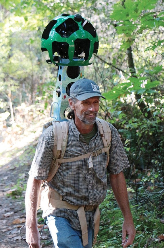
The camera is a 50-pound soccer ball-sized green sphere containing 15 separate lenses and mounted on a backpack
The Google Trekker captures a 360-degree view of its surroundings every 2.5 seconds. Each image is automatically tagged with a GPS location.
The resulting footage will be stitched together by Google and added to the Google Maps and Street View system so anyone with computer access can see what it is like to hike to the summit through Mount Tzouhalem’s coastal Douglas fir forests.
“It’s like Street View, but it takes you to places you can’t access with a car,” NCC west coast stewardship coordinator Katy Fulton said.
The NCC approached Google about the possibility of borrowing the Trekker equipment, and the tech company was immediately interested.
“The Nature Conservancy of Canada is excited about this new collaboration with Google. Now Canadians will be able to virtually visit protected areas that many of them have helped to support,” said Nancy Newhouse, acting regional vice president for NCC in British Columbia.
“We are one of the first groups to take on the Google data collection process ourselves. We are using state of the art technology to digitally map some of our most amazing places.
“When we’re done, people around the world will be able to explore the Nature Conservancy’s projects on Street View,” Newhouse said.
The job of hiking up the mountain with the Trekker on Sept. 15 fell to Irvin Banman, the NCC site manager for Chase Woods and the Cowichan Garry Oak Preserve, and to Luc Thomas, the NCC’s manager of digital services, who has the responsibility of accompanying the equipment to its six destinations across the country. They were joined on the hike by communications manager Lesley Neilson.
The training and equipment for the project have been provided by Google free of charge, and the company is also footing the bill for transporting the gear across Canada.
“Thousands of people hike Mt. Tzouhalem every year, but not everyone is aware of the important ecological significance of the forests here,” Fulton said. “These images will not only allow people to virtually visit this amazing place, but will also educate viewers about the need to protect and restore our coastal Douglas fir forests.”
Fulton hopes that by putting the trail online, the NCC will encourage people to get out and experience it first hand.
“I think it will help get people out there,” she said. “The ecosystem is unique in Canada; we have only one per cent of our old-growth coastal Douglas fir forests left. It attracts huge concentrations of species. The more time you spend there, the more you discover.”
The NCC acquired Chase Woods in 2009 from Cowichan resident David Chase, who stewarded the property’s Douglas fir forest for more than 50 years. Other sites the NCC is documenting with the Trekker include the Old Man on His Back Prairie and Heritage Conservation Area in southwest Saskatchewan; Horseshoe Canyon in the Canadian Badlands in Alberta and the Johnson’s Mills Shorebird Reserve and Interpretive Centre in New Brunswick on the Bay of Fundy. After Mount Tzouhalem, the project will finish up at locations in Quebec and Ontario.